LoveTravelEngland
  • About
    • Who, Why, How
  • The SWCP
    • SWCP Counties
    • Somerset & Exmoor Hikes >
      • Minehead to Porlock Weir
      • Lynmouth to massive storm
      • Lynmouth to Porlock Weir
      • Lynton to Lee
      • Holdstone Down to Lynton
      • Combe Martin to Holdstone Down
    • North Devon Hikes >
      • Ilfracombe to Combe Martin ​
      • Ilframcombe to Morthoe
      • Braunton to Morthoe
      • Barnstable to Fremington Quay
      • Bideford to Appledore
      • Westward Ho! to Appledore
      • Bucks Mill to Western Ho!
      • Buck's Mill to Clovelly
      • Hartland Quay to Clovelly
    • North Cornwall Hikes >
      • Padstow to Trevone
      • Mawgan Porth to Newquay
    • West Cornwall Hikes >
      • Hell's Mouth to Portreath
      • Carbis Bay to Gwithian
      • St Ives to Lelant
      • St Ives to Zennor
      • Zennor to Pendeen Watch
      • Land's End to Sennen Cove
      • Land's End to Porthcurno
      • Lamorna to Porthcurno
      • Penzance to Lamorna Cove
      • Penzance to Marazion
      • Marazion to Porthleven
      • Mullion Cove to Lizard Point
      • Cadgwith to Lizard Point
      • Coverack to Cadgwith
      • Helford Passage to Coverack
      • Falmouth to Helford Passage
    • South Cornwall Hikes >
      • Falmouth to Portscatho
      • Gorran Haven to Pentewan
      • Charlestown to Fowey
      • Charlestown to Pentewan
      • Portwrinkle to Rame Head
    • South Devon Hikes
    • Jurassic Coast Hikes >
      • Seaton to Lyme Regis
      • Abbotsbury to West Bay
  • Fall 2023 Blog

HIKING THE SOUTH WEST COAST PATH

History! Newlyn Tidal Observatory

10/29/2023

 
Picture
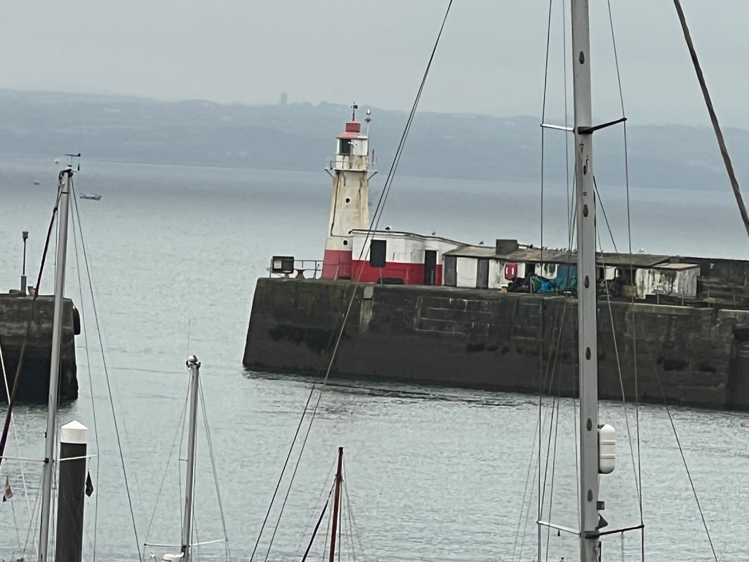
That totally inauspicious-looking building at the end of the pier is the Newlyn Tidal Observatory. And it’s here—right here in Newlyn—where the mean sea level for all of the Uk is identified. This measurement forms the starting point for leveling the whole of the UK. And not just sea levels: how we calculate height above sea level has a direct impact on how high we measure mountains and how deep we measure valleys. You can read all about it here but the short answer is: six years.  ​

Comments are closed.
Powered by Create your own unique website with customizable templates.
  • About
    • Who, Why, How
  • The SWCP
    • SWCP Counties
    • Somerset & Exmoor Hikes >
      • Minehead to Porlock Weir
      • Lynmouth to massive storm
      • Lynmouth to Porlock Weir
      • Lynton to Lee
      • Holdstone Down to Lynton
      • Combe Martin to Holdstone Down
    • North Devon Hikes >
      • Ilfracombe to Combe Martin ​
      • Ilframcombe to Morthoe
      • Braunton to Morthoe
      • Barnstable to Fremington Quay
      • Bideford to Appledore
      • Westward Ho! to Appledore
      • Bucks Mill to Western Ho!
      • Buck's Mill to Clovelly
      • Hartland Quay to Clovelly
    • North Cornwall Hikes >
      • Padstow to Trevone
      • Mawgan Porth to Newquay
    • West Cornwall Hikes >
      • Hell's Mouth to Portreath
      • Carbis Bay to Gwithian
      • St Ives to Lelant
      • St Ives to Zennor
      • Zennor to Pendeen Watch
      • Land's End to Sennen Cove
      • Land's End to Porthcurno
      • Lamorna to Porthcurno
      • Penzance to Lamorna Cove
      • Penzance to Marazion
      • Marazion to Porthleven
      • Mullion Cove to Lizard Point
      • Cadgwith to Lizard Point
      • Coverack to Cadgwith
      • Helford Passage to Coverack
      • Falmouth to Helford Passage
    • South Cornwall Hikes >
      • Falmouth to Portscatho
      • Gorran Haven to Pentewan
      • Charlestown to Fowey
      • Charlestown to Pentewan
      • Portwrinkle to Rame Head
    • South Devon Hikes
    • Jurassic Coast Hikes >
      • Seaton to Lyme Regis
      • Abbotsbury to West Bay
  • Fall 2023 Blog